 Civil & Survey Engineering Design |
“SALEM Engineering Group, Inc.’s network of land surveying professionals bring years of experience and knowledge of the industry to provide solutions to a variety of land planning needs.”
Our team has provided land surveying, mapping and legal document services to a variety of clients throughout the western United States. Past land surveying projects have included ALTA Surveys, topographic surveying, boundary surveys, and tentative and final mapping services for commercial and private development, lot line adjustments for real estate developers and right-of-way dedication and construction staking for the construction of a large scale retail development center. Our staff is able to service the project throughout the life cycle including during construction by providing construction staking services in a timely manner.
ALTA/ACSM Land Title Survey
An American Land Title Association (ALTA) Survey is a detailed map of a property that delineates the property line and includes all improvements within, including the building footprint and all significant observations. An ALTA Survey also includes easements, exceptions and additional information included in the Title Report for the property. Typically, an ALTA Survey is a requirement for extending Coverage Title Insurance as part of a real estate transaction.
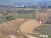
Topographic Survey
This type of survey locates topographical features such as buildings, improvements, trees, waterways and vertical elevations. The survey is used in a variety of applications but most commonly in the development of precise grading plans and Civil Engineering Design.
As-Built Surveys & Certification
An As-Built Survey is a detailed map that includes all improvements and site features of the property at a given time. Typically, an As-Built Survey is conducted to record variations and certify construction was completed in conformance with the approved engineering plans.
Easement, Legal Description and Right-of-Way Dedication
Development of legal descriptions and exhibits indicating the location of easements which allow for the right to use real property of another for a specific purpose. Right-of-way dedication is commonly reserved for the purpose of expansion of existing services within the right-of-way and are common in commercial development at the request of the local municipality.
Tentative and Final Mapping
Development of maps for proposed parcel configuration prior to the recordation of a final map. Our staff of surveyors has developed tentative and final maps for small scale strip mall retail projects upwards to large scale commercial development.
Lot Line Adjustments
A Lot Line Adjustment is a common procedure that is used to make minor revisions to property lines between two or more existing parcels, including combining adjacent parcels into one, and/or reconfiguring shapes of existing parcels. A lot line adjustment process will result in producing the same number of parcels.
Boundary Survey
A Boundary Survey is produced for the purpose of locating the property corners, boundary lines and/or easements of a given parcel of land. Our team researches public records and conducts field reconnaissance to establish boundary lines in conformance with the Professional Land Surveyors Act.
Record of Survey
A Record of Survey (ROS) is prepared and sealed by our team of professionals identifying the boundaries of land and real property, and the location or placement of other improvements. Typically, a ROS is required for a property to be recorded with the County Recorder’s Office.
Construction Staking
Our team of surveying professionals utilize the engineer or architect’s approved plans to place stakes in the ground that serve as reference points to guide construction of proposed improvements on the property. This is conducted to ensure a project is built according to plan.
Underground Utility Locating Services
There are instances where surface elements of underground utilities are not visible due to a various reasons. Our professionals use specialized equipment to locate underground utilities in order to property locate them on the surface, which are then picked up during the topographic survey.
Related Services

Biological Resources
SALEM utilizes strategically aligned Registered Professional …

Drilling
“Our Mission is to develop long-term relationships by providing …
Geotechnical Engineering
SALEM Engineering Group, Inc. offers a wide range of geotechnical …

Land Use Planning
Our team of certified professionals have provided environmental …